Lazio, Italy

Lazio ๑ Italy ๑ travel ๑ map ๑ info ๑ what to see in ๑ how to go to ๑ opening hours ๑ address ๑ advices ๑ curiosity ๑ recipes ๑ accommodation ๑ photos


colosseo-roma-01-travelmapitaly.com

Lazio


About Lazio

Basic Information:

  • Region: Lazio
  • Region Center: Roma
  • Zona: Central Italy, on the Tyrrhenian Sea
  • Provinces: 5 - Frosinone, Latina, Rieti, Roma, Viterbo
  • Municipalities: 378
  • Surface: 17 236 km ²
  • Population: 5 764 389 (by 30/09/2011)
  • Web site: Official Web Site


Lazio is the region of Italy where it is situated Roma - the capital city of Italy. Besides this Lazio has a great artistic and cultural heritage and so why this makes the region to be the most favorite tourist destination not only in Italy but also all over the world. In the area of Roma it is situated also Vatican City, which attracts many religious pilgrims during all the year.

There are many other interesting archaeological sites to visit like Tarquinia and Cerveteri, seaside towns Gaeta, Anzio, Sabaudia, San Felice al Circeo, famous spas like Fiuggi.

In the region of Lazio are in the Park of Circeo National Park and a part of National Park Abruzzo.

The cuisine of Lazio has popular origin. Between its typical dishes are the Bucatini all'Amatriciana or alla Carbonara and among the desserts are the Macaroni to the nuts and Easter Cake. In Lazio are produced more than 24 DOC wines.


What to see in Lazio?

Choice the places to see in Lazio here or from the menu on the left:

  • Roma
  • Viterbo
  • Frosinone
  • Latina
  • Rieti


How to go to Lazio?

As it is used to said in all the countries of the world "All the roads lead to Rome".

All the roads leads to Roma and All kind of transport you get you will easily reach Roma and Lazio:
- by Airplane, Train, Bus, Car, Ship or Boat.

For more information take a look at the main city you would like to visit.


Accommodation, Hotels, Rooms, Bed and Breakfast, Agritourism and More

  • Cannot find your place? - It is Easy - Check on the Banner links on TravelMapItaly!
  • Wanna be Our Sponsor or Recommend Your Accommodations? - Simply Contact TravelMapItaly.


Map of Lazio


Random Pictures


Civita di Bagnoregio, Viterbo, Lazio, Italy

Civita di Bagnoregio ๑ Viterbo ๑ Lazio ๑ Italy ๑ Italia ๑ travel ๑ map ๑ info ๑ what to see in ๑ how to go to ๑ opening hours ๑ address ๑ advices ๑ curiosity ๑ recipes ๑ accommodation ๑ photos

civita-di-bagnoregio-01-travelmapitaly.com

Civita di Bagnoregio


About Civita di Bagnoregio

civita-di-bagnoregio-02-travelmapitaly.comBasic Information:


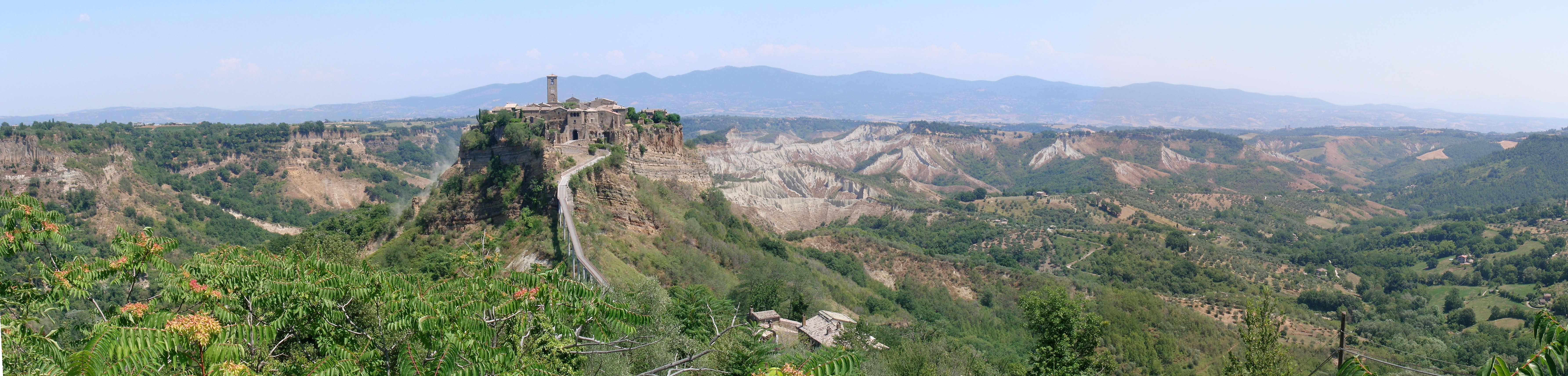
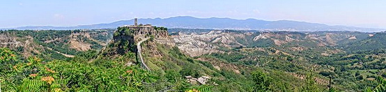
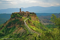
Civita di Bagnoregio is a village in the municipality of Bagnoregio, famous for being called "The Dying City". Civita di Bagnoregio is called also as an Open Air Museum.


Curiosity

Located in a secluded, is only accessible via a pedestrian bridge in reinforced concrete built in 1965. The bridge can be crossed only on foot, but recently the town of Bagnoregio, to meet the needs of those who live or work there has issued a circular stating that at certain times residents and authorized persons can cross the bridge on the edge of cycles and motorcycles. The cause of his isolation is the gradual erosion of the hill and the surrounding valley, which has given rise to the typical forms of the ravines and that continues today, threatening to wipe out the village, for this also Civita di Bagnoregio is called "The Dying City" or more rarely "The Dying Town".

The village is currently inhabited by six people.


A little History about Civita di Bagnoregio

Civita di Bagnoregio was founded 2500 years ago by the Etruscans. It stands on one of the oldest streets in Italy connecting the Tiber (then great waterway of Central) and Lake Bolsena.

The ancient town of Civita is accessed by five doors while today there is only one door called Santa Maria della Cava, it is the only one access to the country.

The urban structure of the entire town is of Etruscan origin, consisting of thistles and decumans according to the custom Etruscan and Roman, while the entire coating is medieval and Renaissance architecture. There are numerous testimonies of the Etruscan phase of Civita, especially in the area known as old San Francesco where it was found a small Etruscan necropolis. Even the cave of San Bonaventura which it is says that San Francesco healed a little Giovanni Fidanza who later became San Bonaventura is actually an Etruscan chamber tomb.

The Etruscans made Civita di Bagnoregio (we do not know the ancient name of it) a thriving town favored by the strategic position for trade, thanks to its proximity to the most important roads of the time. There are many testimonies of the Etruscan period: of particular fascination is the "Bucaione" which is a deep tunnel that cuts through the lower part of the town and that allows access from the country, the Valley of the Badlands.

In the past they were also seen many tombs, rooms at the base of the cliff of Civita and other surrounding tufa walls which unfortunately were largely swallowed up over the centuries by countless landslides.

For the rest the Etruscans had already the problems of instability and seismicity of the area who in 280 BC passed lots of earthquakes and landslides. When the Romans came in 265 BC they were shooting the mighty works of channeling rainwater and containment of the streams initiated by the Etruscans.

Today Bagnoregio continues to be a small but prosperous town, while Civita became known as "The Dying Town". Civita di Bagnoregio has only recently been experiencing as a tourist revival.


What to see in Civita di Bagnoregio?

Inside the village there are several Medieval Houses, the Church of San Donato overlooking the main square. Take a look at the SS Wooden crucifix which houses inside the Church of San Donato.

Take a look also at the Bishop's Palace, a Mill of the XVI century, the Birthhouse of San Bonaventura and the Port of Santa Maria with two lions holding between his paws a human head, that is in a memory of a popular uprising against the inhabitants Monaldeschi family from Civita Orvieto.

In 2005 the Badlands of Civita di Bagnoregio have been proposed as a Site of Community Interest.

In 2006 the town of Civita di Bagnoregio was placed on the World Monuments Fund's List of the 100 Most Endangered Sites, due to the threats it faces from erosion and unregulated tourism.


The Museum of Geology and Landslides

The Museum of Geology and Landslides of Civita di Bagnoregio due to its unique location presents itself as a place of synthesis and exhibition of the natural qualities of the area between Lake Bolsena and the valley of the Paglia and Tiber rivers. As a center of study and interaction for those (academics, professionals or amateurs) which belong to various disciplines such as engineering, archeology, agronomy, and earth sciences: geology

applied geomorphology, hydrogeology, stratigraphic geology, volcanology, mineralogy, paleontology molluscs and vertebrates.

The Museum was inaugurated on 23 April 2012 and surely it will surprise you of what you can see there.


Opening Hours

Winter months:

March 1 - May 31 October 1 - January 6:

Friday - Sunday: 10.00 - 13.00 14.00 - 18.30

Tuesday - Thursday: only with a booking for at least 25 people.


Summer months:

June, July, August, September:

Tuesday - Sunday: 9.30 - 13.00 14.00 - 18.30


Special Openings:

December 26, January 6, Monday of Easter.


Closed:

Monday, December 24, 25, 31, January 1

From January 7 to 28 (29) February.


Address of The Museum of Geology and Landslides

MUSEO GEOLOGICO E DELLE FRANE

Palazzo Alemanni

Piazza San Donato

Civita di Bagnoregio (VT), Italy

☎ +39 328 66 57 205


How to go to Civita di Bagnoregio?

    • By Air

Civita di Bagnoregio is situated 130 km from the capital city of Italy so in all case flying to Roma is the most convenient way for you to rich the city. From the train station Termini in Roma you can get a train for Orvieto or Viterbo.

For more information visit the Airports of Roma web sites:

Roma Airport 1 - International Airport Leonardo Da Vinci - Fiumicino

Roma Airport 2 - International Airport Ciampino

The both have very good connection with the city of Roma where you can make some connection.


    • By Train

If you prefer to go to Civita di Bagnoregio you should stop in Viterbo or Orvieto. From there you can take the a bus lines COTRAL to Bagnoregio.

For more information visit the Italian Railway web site.


    • By Car

If you come from North via Highway A1 you should exit in Orvieto and then to get SP12 and after SP6 to Bagnoregio.

If you come from Roma via Highway A1 you could exit in Attigliano and travel via country changing several ways: SP19, SP132, SP5 (or SP131) and SP6 to Bagnoregio.

Coming from Viterbo, Bagnoregio is easy reachable via SP5 and SP6.


    • Go Around

The only way to visit Civita di Bagnoregio is walking passing the long bridge and the Door Santa Maria della Cava.

If you go by Camper or BUS you should leave it in the parking Piazzale Battaglini at the beginning of the city.

There is a public transport: Piazza S. Agostino - Loc. Mercatello (access to the Bridge to Civita di Bagnoregio).

The way back is: Loc. Mercatello - Piazzale Battaglini.


Accommodation, Hotels, Rooms, Bed and Breakfast, Agritourism and More

  • Cannot find your place? - It is Easy - Check on the Banner links on TravelMapItaly!
  • Wanna be Our Sponsor or Recommend Your Accommodations? - Simply Contact TravelMapItaly.


Map of Civita di Bagnoregio


Random Pictures


Vatican Hill, Vatican City State, Roma, Lazio, Italy

Vatican City State ๑ Città del Vaticano ๑ Vatican Hill ๑ Vaticano ๑ Roma ๑ Rome ๑ Lazio ๑ Italy ๑ travel ๑ map ๑ info ๑ what to see in ๑ how to go to ๑ opening hours ๑ address ๑ advices ๑ curiosity ๑ recipes ๑ accommodation ๑ photos


Vatican City State (Stato della Città del Vaticano)

About Vatican City State

  • Capital: Vatican City
  • Situated in: the center of Roma city
  • Zona: Roma, Central Italy
  • Political State: Independence from Italy
  • Government: ecclesiastical, sacerdotal-monarchical, absolute, elective monarchy
  • Sovereign: Pope Benedict XVI
  • Coordinates: 41°54.2′N 12°27.2′E
  • Surface: 0,44 km ²
  • Population: 994 (by 31/07/2011)
  • Saint Day: 11 February
  • Web site: Official Web Site


Vatican City State is the world famous center of Catholicism. The government of Vatican City has a unique structure. The Pope is the sovereign of the state. The current office-holder is Pope Benedict XVI who was elected in a papal conclave on 19 April 2005. He is the Bishop of Rome and the leader of the worldwide Catholic Church.

More History about Vatican City State

For advanced information check the Official Web Site of Vatican City State.


What to see in Vatican City State?

St. Peters Basilica

The Papal Basilica of Saint Peter (Basilica Sancti Petri) is well known in Italian as Basilica Papale di San Pietro in Vaticano and commonly known as Saint Peter's Basilica. The Basilica is a Late Renaissance church located within the Vatican City. Saint Peter's Basilica will surprise you with the largest interior of any Christian church in the world. While it is neither the official mother church of the Roman Catholic Church nor the cathedral of the Pope as Bishop of Rome Saint Peter's is regarded as one of the holiest Catholic sites. It has been described as "holding a unique position in the Christian world" and as "the greatest of all churches of Christendom".

More History about The Saint Peter's Basilica


The Vatican Museums

The Vatican Museums (Musei Vaticani), in Viale Vaticano in Rome, inside the Vatican City are among the greatest museums in the world, since they display works from the immense collection built up by the Roman Catholic Church throughout the centuries, including some of the most renowned classical sculptures and most important masterpieces of Renaissance art in the world.

More History about Vatican Museums


The Vatican Gardens

The Vatican Gardens (Giardini Vaticani) in Vatican City are urban gardens and parks which cover more than half of the Vatican territory in the South and Northeast. There are some buildings such as Radio Vatican within the gardens.

The gardens cover approximately 23 hectares (57 acres) which is most of the Vatican Hill. The highest point is 60 meters (200 ft) above mean sea level. Stone walls bound the area in the North, South and West.

More about Vatican Gardens


How to go to Vatican City State?

The Vatican City State is on the Vatican Hill in Rome on the right bank of the river Tiber.

How to go to the Vatican City in Rome you can check also in the page:

Roma => How to go to Roma?


Accommodation, Hotels, Rooms, Bed and Breakfast, Agritourism and More

  • Cannot find your place? - It is Easy - Check on the Banner links on TravelMapItaly!
  • Wanna be Our Sponsor or Recommend Your Accommodations? - Simply Contact TravelMapItaly.


Map of Vatican City State


Random Pictures


L - V

O ๑ O ๑ O ๑ O ๑ O ๑ Italy ๑ travel ๑ map ๑ info ๑ what to see in ๑ how to go to ๑ opening hours ๑ address ๑ advices ๑ curiosity ๑ recipes ๑ accommodation ๑ photos


O ๑ O ๑ O ๑ O ๑

A


About A

Basic Information:

  • City: A
  • Region: A1
  • Province: A
  • Zona: Italy
  • Coordinates: 0
  • Surface: 0 km²
  • Population: 0 (by 0/0/201)
  • Patron Saint:
  • Saint Day:
  • Web site: Official Web Site


What to see in A?

A1


More info

How to go to A?

    • By Air


For more information visit the International Airport Napoli web site.


    • By Train

For more information visit the Italian Railway web site.


    • By Car


    • Go Around


Accommodation, Hotels, Rooms, Bed & Breakfast, Agritourism and More

Are you looking for Accommodations, Hotels, Rooms, Bed & Breakfast, Agritourism, Farm Holidays, Farmhouse, Holiday Homes, Guest House, Villas, Castles, Hostels, Residences, Apartments, Camping, Mountain Hut, Campsites and Alpine Huts, Religious Institutions in Italy?

  • If you are looking to organize your trip to Italy and need accommodation take a look at the Links AdChoices by Google on the page here.

For those who would like to become Our Sponsors?

  • If you would like to suggest and add your place in Recommended Accommodations in your area, please Contact TravelMapItaly for more information and become our sponsor.


Map of A

{iframe }http://maps.google.it/maps?t=h&hl=it&ie=UTF8&source=embed&ll=44.927134,10.37487&spn=0.047339,0.06609&z=14&output=embed{/iframe}
View Larger Map

Random Pictures

{iframe}http://www.panoramio.com/wapi/template/slideshow.html?width=400&height=348&bgcolor=%23EBF3F5;tag=A{/iframe}


Flavian Palace, Palatine Hill, Seven Hills, Roma, Lazio, Italy

Flavian Palace ๑ Domus Flavia ๑ Seven Hills of Rome ๑ Sette colli di Roma ๑ Roma ๑ Rome ๑ Lazio ๑ Italy ๑ travel ๑ map ๑ info ๑ what to see in ๑ how to go to ๑ opening hours ๑ address ๑ advices ๑ curiosity ๑ recipes ๑ accommodation ๑ photos


Flavian Palace (Domus Flavia)

About Flavian Palace

Flavian Palace, also known as Domus Flavia, is a part of the vast residential complex of the Roman Emperors on the Palatine Hill in Rome. It was completed in 92 AD in the reign of Titus Flavius Domitianus well known as the Emperor Domitian and attributed to his master architect, Rabirius.


Opening Hours

January 2 - February 15: 8.30 am - 4.30 pm

February 16 to March 15: 8.30 am - 5.00 pm

March 16 - last Saturday of March: 8.30 am - 5.30 pm

Last Sunday of March - August 31: 8.30 am - 7.15 pm

September 1 to September 30: 8.30 am - 7.00 pm

October 1 - last Saturday of October: 8.30 am - 6.30 pm

Last Sunday of October - December 31: 8.30 am - 4.30 pm

Last admission 1 hour before closing time.

Closed: January 1, December 25.

Last admission one hour before closing time.


The ticket, which is valid for the Colosseum and Palatine, may be purchased at the ticket offices in Via di San Gregorio (Palatine), Largo Salara Vecchia - Former Largo Romolo e Remo (Roman Forum) and Piazza del Colosseo (Colosseum). The exits are located at the Arch of Titus and the Mamertino prison (closed both entrances and exits at S. Teodoro and at Capitoline hill).


Please Note: Booking for individual visitors is not required at the Roman Forum and the Palatine Hill. All tickets booked by phone or online (also Roman Forum and Palatine Hill tickets only) must be collected at the Coliseum's Ticket Window.


Inside the archaeological site (Roman Forum and Palatine), at no additional cost, you can visit the following monuments:

- House of Augustus

October 31 - April 30

Monday: open for scholars only from 8.30 am to 11.00 am; open to the public from 11.00 am to 3.30 pm (closing time of the Palatine Hill);

Wednesday, Saturday and Sunday: 11:00 am to 3.30 pm (closing time of the Palatine Hill);

Tuesday, Thursday and Friday: closed;

- Vigna Barberini (an artificial terrace in the northeastern corner of the Palatine): following the regular opening hours of the site;

- Arcate Severiane:

October 31 - April 30

Tuesday, Thursday and Friday: 8.30 am to 4.00 pm;

- Temple of Romulus: from 8.30 am to closing time of the Palatine Hill/Roman Forum;

- House of Livia and Oratory of the Forty Martyrs: closed until further notice.

- Temple of Venus and Roma: following the regular opening days and hours of the site.


The Museum is included in Roma Pass and Archeologia card.

Combined Ticket valid for 2 days: Colosseum + Roman Forum + Palatine Hill.

Address

Via di San Gregorio, Roma

☎ +39 06 39967700 (from 9.00 to 13.00 and from 14.00 to 17.00 from Monday to Friday, Saturday from 9.00 to 13.00)

Official office - Buy Tickets Online

e-mail:


Always check online on their official web sites for news!


Accommodation, Hotels, Rooms, Bed and Breakfast, Agritourism and More

  • Cannot find your place? - It is Easy - Check on the Banner links on TravelMapItaly!
  • Wanna be Our Sponsor or Recommend Your Accommodations? - Simply Contact TravelMapItaly.


Map of Palatine Hill


Random Pictures